Seeking the location of Bride's Well
How accurate is the position St Bride’s Well Stone?
The historic site of Bride’s Hill holds the site and footings of the early Brigid Chapel and burial site, but the FoBM land holds a site featured in more recent Glastonbury mythology. This was where the Blue Bowl was hidden in 1898, sometimes said to be Bride’s Well. The tale of the Blue Bowl links Bride’s Hill, Chalice Well, and some luminaries of the early-twentieth century revival of mystical Glastonbury. Patrick Benham, erstwhile editor of the 1970s alternative magazine Torc called this group The Avalonians, and the story of the Blue Bowl is told well in his book 1 of the same name. The whereabouts of this feature is of interest to some modern pilgrims, and there’s some doubt about its location due to 20th century hydrological work.
I have set out to examine this, using Dr John Goodchild’s sketch map, historical mapping and post-war aerial photography. We now have the privilege of some quite large scale historical mapping available online, which can be displayed side-by side with georeferenced aerial mapping.
Wellesley Tudor Pole described the discovery in a letter dated 20 May 1963 in ‘My dear Alexias’ (letters from WTP to Rosamond Lehman) where he says
The Cup of Peace […] came to light at St Bride’s Well (or Source) near the Brue Stream, Glastonbury in October 1906
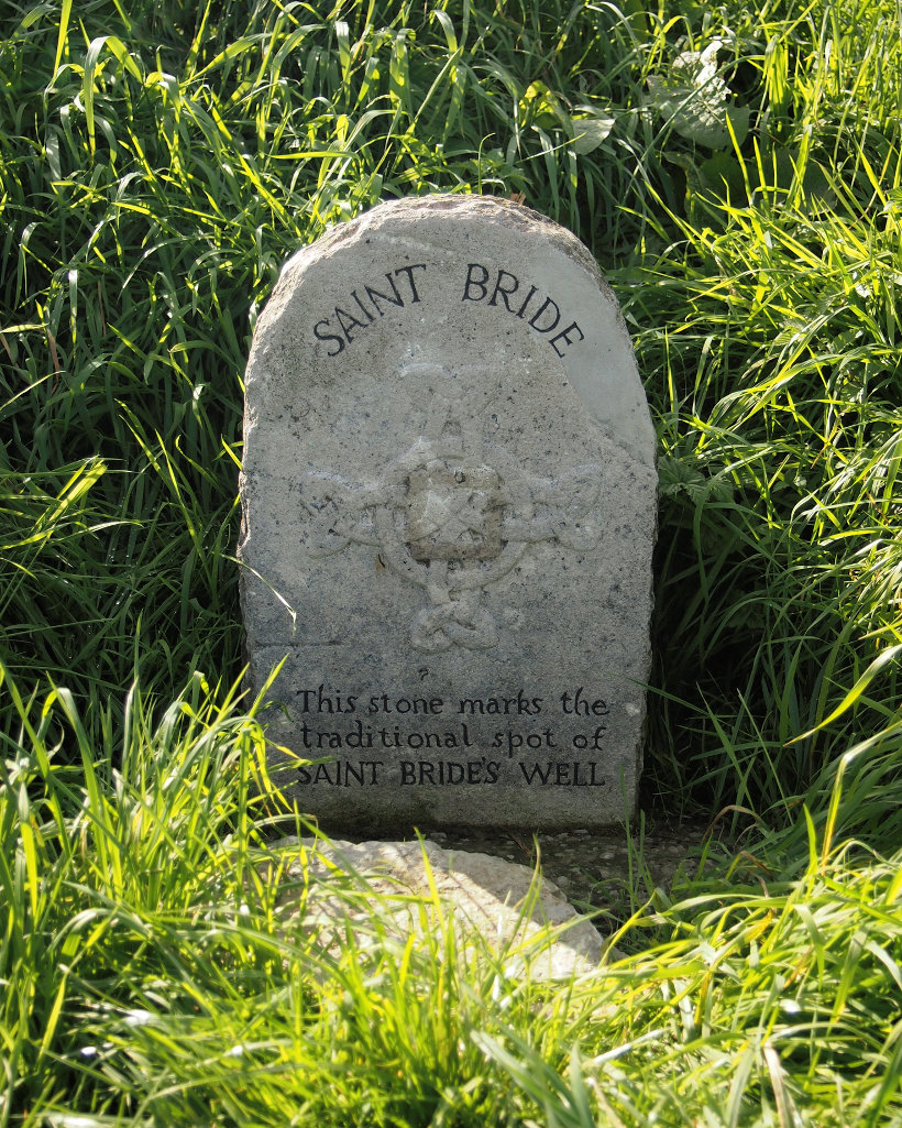
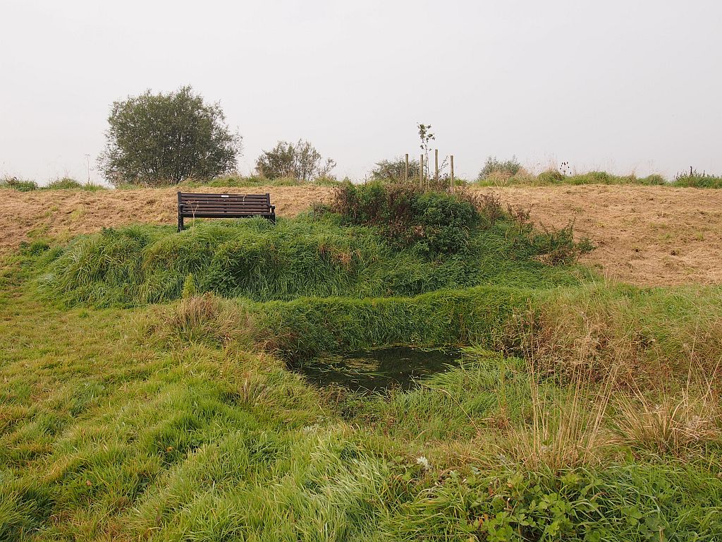
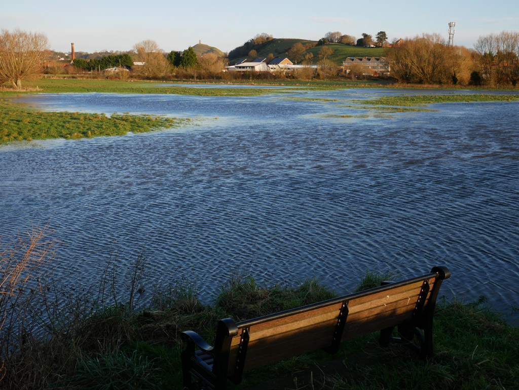
It’s hard for the 21st century pilgrim to make sense of this in the modern landscape. There’s an obvious pool at ST481381, with a convenient bench to gather her thoughts, and a long embankment that canalises the river Brue - this was not present in the Avalonians' time. A couple of hundred metres northwards along the bank at ST481383, part of the way down, there is a stone proclaiming “This Stone Marks The Traditional Spot of Saint Bride’s Well”.
The pilgrim may think that halfway up an embankment is a rum place to put a well. The ground isn’t particularly marshy here, how do I relate this to the Blue Bowl and Dr Goodchild? The misdirection of the pool a 200 metres further south adds to the uncertainty, since it’s an obvious candidate for Bride’s Well.
Dr John Goodchild’s Blue Bowl
A hidden object symbolic of the Holy Grail, three maidens guided by mystical visions on a quest, it’s a great yarn and one of the myths of Avalon. An early psychic quest, if you like. One author postulated2 an alternative explanation that this may have been part of an esoteric ritual.
Dr Goodchild was inspired by a vision he had in Paris in the previous year that he should take the Blue Bowl (a.k.a the Cup) soon after his father’s death in 1898 to Beckery, known the Women’s Quarter3 in Glastonbury. He made the journey in August staying in the town, it was only in September than his inner voice told him what to do with the object. On Monday the 5th September 18984 he was directed to Bride’s Well where he hid the Blue Bowl under a stone in the water.
Bride’s Well is not shown on any old maps of the area. Goodchild did sketch a map of the area, reproduced in The Avalonians (p40). Goodchild’s cartography is a little bit funky where it comes to scale, but where the rhynes and field boundaries meet up he is reasonably accurate. In a hand-drawn sketch map - marked items line up up OK as you see them in the field, but featureless areas may not be to scale and angles aren’t always right.
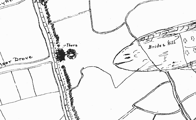
The shaded element with Bride’s Hill marked is a piece of raised ground, which includes the Chapel site and used to extend further back. You can still see this on the ground, and it probably assisted the fifth century pilgrims as they approached the holy site of the chapel across the marshes. Noteworthy is that Goodchild does not mention Bride’s Well.
In Goodchild’s day the thorn would be visible to the right of this picture, approximately where the power pole can be seen faintly in the photo.
matching map to territory
The most valuable OS map set for this project is the OS 25 inch to the mile map of the area from 1888, some ten years before Dr Goodchild concealed the Blue Bowl. This can be viewed against a recent aerial photo at the National Library of Scotland.
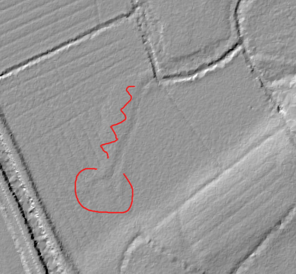
Correlating Dr Goodchild’s sketch with the OS map, the clyce seemed to be on the eastern side of the river, opposite where the northernmost rhyne along Hulk Moor Drove approaches the Brue from the west. From the NLS overlay5 you can see that most of the clyce has been covered by the embankment and the path has been shifted a little bit east - this is because raising the embankments needed a slope on both sides for stability. The embankment covers the original sluice entirely.
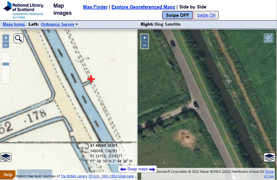
The NE end of the stub showing the clyce is at ST 4807 3829. Bing Maps aerial photography is not quite detailed enough to pick up the stone, the Environment Agency’s LIDAR DTM 50cm overlay6 is just enough to pick up the stone at ST 4807 3830
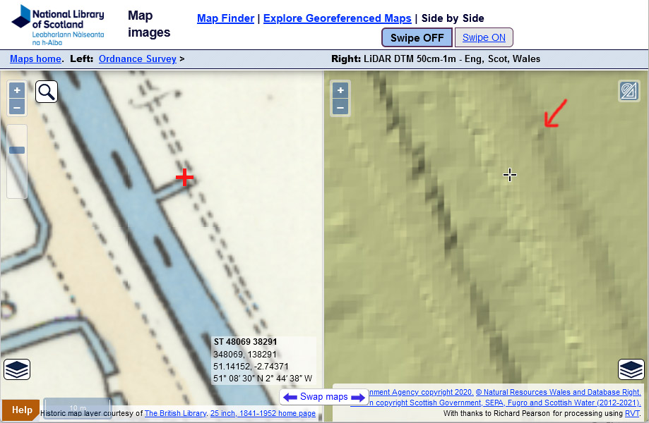
Assuming the georeferencing7 is good , the stone is within 10m of the NE end of the clyce shown on the 1888 OS map. For practical purposes it’s good enough.
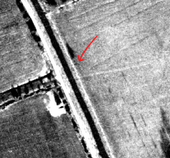
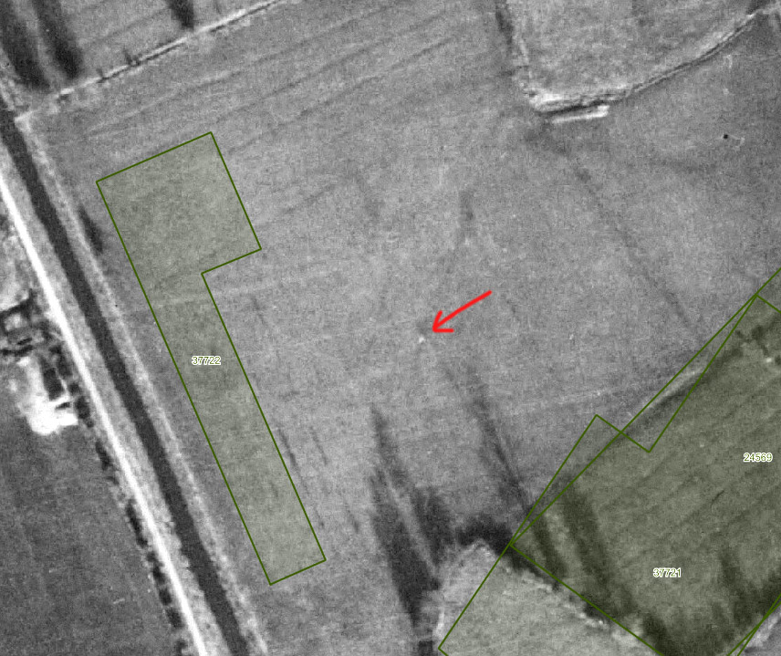
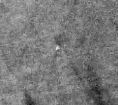
To second-source this I used a good resource looking at details of geophysical surveys taken in the area on Somerset Historic Environment Record. If you select mapping - RAF Aerial photos (c1946) you can see the faint outline of the site and an adjacent tree that casts a long shadow in the low light; I have pushed the contrast on this extract.
Further south, Geophys survey 41517 states :
A small excavation 1m x 4m was opened over an feature located on a geophysical survey (37722). This recorded only modern rubble that had probably been use to infill a ditch known from maps.
This was excavated near to the pool at ST 4818 3808 8, which is another field ditch on the opposite side of the Brue to where a rhyne runs parallel to Hulk Moor drove. John Goodchild’s sketch map does show that rhyne, and the still extant hedgerow, but it does not show anything particular there. This is approximately 190m along the bank from the current location of the stone.
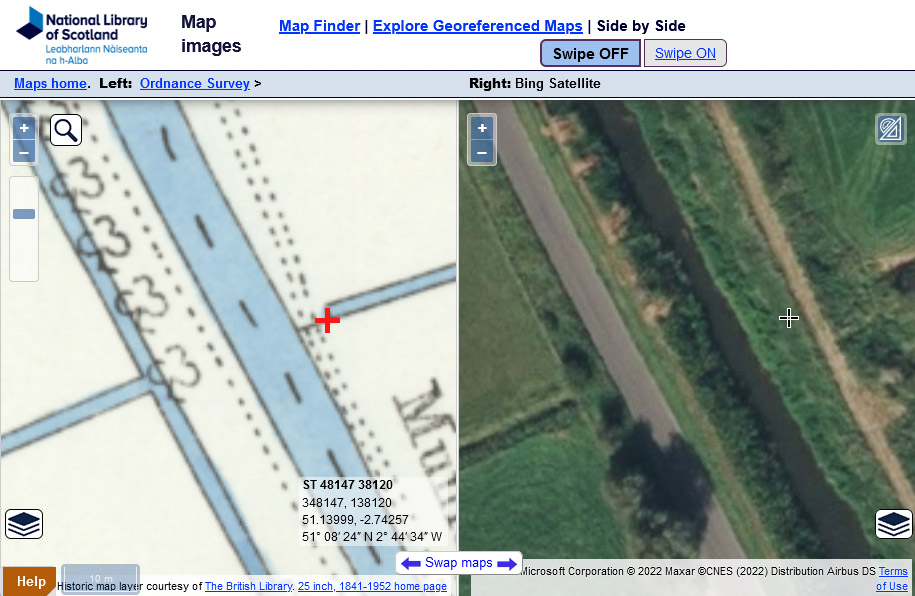
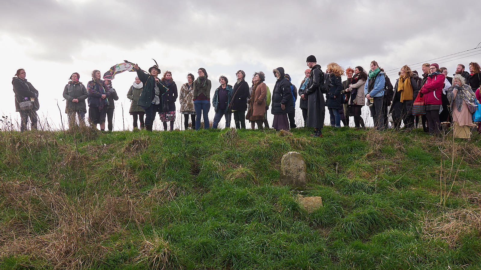
the stone is close to where the Blue Bowl was found
Some of these pilgrims are standing a couple of metres above where Janet and Christine Allen located the Blue Bowl, and Kitty Tudor-Pole recovered it in 1906.
The stone was clearly moved at least once when the embankment was built, so while the stone does now closely mark what Wellesley Tudor Pole thought of as Bride’s Well, maybe Bride’s Well and the stone predate the Blue Bowl escapade, and the stone most likely marked a different place when first set.
Bride’s Well?
It is possible that there was a spring in the field, apart from the location shown by John Goodchild in his sketch map. He only calls out the thorn tree, which is by the clyce. Goodchild didn’t live in Glastonbury when he placed the Blue Bowl in what he called Bride’s Well, so perhaps he misnamed it initially. He explicitly repudiated it being hidden in the well in 1907.
The site is described a little more in newspaper reports from 19079:
He [WTP] saw, either in a “dream” or so clearly with his mind’s eye that it seemed a “vision,” a spot which he remembered well - a small rivulet and a pond on some farm land known as Bride’s Hill, about half a mile from Glastonbury Abbey. In the shallow well, or spring, which is the source of the rivulet, he saw buried a small vessel. Mr Pole sent his sister and two other ladies, one of whom is a “clairvoyante,” to the spot. Turning over the mud in the well the ladies found, among other things, the mysterious glass vessel. Mr Pole’s sister and the other ladies were so deeply impressed with the discovery of the glass vessel that they forebore to take it away. Having carefully washed it they replaced it in the well, and returned to Bristol with the other objects which they had unearthed, which included a small cross and gold chain and a carbuncle jewel.
Subsequently Mr. Pole’s sister and other ladies went to Bath, and described to Dr. Goodchild the cup they had found. and which he recognised at once as one which he himself had placed in the well in the year 1898 or eight years before.
In his letter to the Express correcting some factual errors about the discovery of the Cup Goodchild says this
the place of deposit is neither a well nor a spring, but a sluice, locally a clyce, under a thorn by the river Brue
Given this testimony, if the stone is an accurate marker for where the Blue Bowl was hidden, as seems likely from the sketch map and corroborated by the old OS map and aerial photography, then it is inaccurate as a marker for the position of Bride’s Well. The FoBM 2015 newsletter10 states:
Philip Rahtz excavated Brides Mound in the 1967–8 on behalf of the Chalice Well Trust. He writes: “Another attraction of the area was a spring. Associated with this was St. Bride’s Well. In the 1920s this was a shallow basin among brambles, marked by an inscribed stone. Unfortunately, the stone was later moved; it is now 100m (330ft) away, the original site is thus lost, but was presumably near the spring.”
Several series of old OS maps of the area are available, and not one of them show a well in this field. The OS doesn’t have anything against showing water appearing in the middle of a field, eg the nearby spring on Wearyall Hill at ST49543813 which is still shown on modern Explorer maps, and the 1888 series shows several wells, including Chalice Well. This would hint that Bride’s Well itself was dry by the time the Blue bowl was concealed in 1898, the survey for the oldest large-scale map must have happened before publication in 1888. The inscription on the stone that it ‘marks the traditional spot of Saint Bride’s Well’ implies the well was no more.
Rahtz’s source could still be right, as time passed and mechanisation happened it could be a right pain to have a stone out in the middle of a field.
Examining the LIDAR11 display more closely, there is a possible anomaly leading from the north-east to ST 4816 3825. This could be a result of flooding, and the rhyne overflowing at the sharp bend at ST 4821 3835.
On its own this would not be that remarkable, the maps at least show it isn’t of historical manmade features like hedgerows. Compare it with the equivalent Somerset HER RAF aerial photo
You can just make out the track of the LIDAR anomaly on the aerial photo in the low light, but there seems to be an object at ST 4816 3825. That matches with the slightly rounded end of the LIDAR anomalous track, which could be where a pool was. It’s a little bit of a stretch to match Rahtz’s “this was a shallow basin among brambles”. Bride’s Well was never a significant water feature, unless it dried up before the first OS survey published 1888.
Squint at this anomaly and it could be the stone, there’s a hint of a shadow so it probably isn’t a speck on the negative. The stone is not a big object and the detail isn’t really there, it’s all too easy to see what you are looking for. Unfortunately it’s a long way away from the resistivity surveys so they won’t have picked anything up there.
There’s another almost point anomaly at ST48293832, on the LIDAR plot and ST48303832 on the aerial mapping. This throws no shadow, and the northern point of unpublished geophys survey 24569 grazes it. Presumably it didn’t flag up anything of interest there. It’s a shame these surveys are not published.
This is a fairly speculative long shot, but if the stone used to be at ST 4816 3825 then it has been co-opted to show a different place of significance, the place the Blue Bowl was concealed, rather than the well. We don’t know the timeline of the stone being shifted or the embankment. It’s fairly clear the embankment was not there in the RAF overflight in 1946. If the well was out in the middle of the field at ST 4816 3825, whoever maintained the field probably doesn’t want a stone stuck out in the middle! It serves well in its current site, as modern pilgrims are perhaps more interested in the mythology of the Blue Bowl.
I haven’t seen water pooling at ST 4816 3825 after rain, although now I have a possible target I may look more closely at this spot, or perhaps for crop shading in summer. A resistivity survey is probably too dear ;) Nowadays the topology tends to flood the southern fields first.
finding the stone on the ground
I failed several times in previous years to find the stone, and literature was sketchy before FoBM bought the land. In summer the pilgrim could be bushwhacking waist-high nettles on the footpath from Pomparles Bridge, or mud in winter. It’s easier to find the stone since FoBM have been managing the site.
I find it easiest to locate the stone coming from Porchestall Drove, walking up from town along the route of the FoBM pilgrimage. There is a footpath along the Brue on the eastern embankment. Pass through the gate at Cradle Bridge onto the embankment. Continue through another two metal gates.
Although rather un-mystical, you will see some power lines cross the river and embankment obliquely. The stone is halfway down the embankment on the left hand side of the path near where the power lines cross. You are looking for this.
references
-
Patrick Benham, The Avalonians, Gothic Image Press, 1993 rev 2006 ↩︎
-
Osborn, L. L. C. (2019). Alice Buckton's Glastonbury Pilgrimage. Presented at ABS Conference Oxford. Lil LC Osborn says: The pilgrimage was certainly used by one esoteric order, The Order of the Table Round (OTR).Wellesley Tudor Pole encountered the Order through Neville Meakin. ↩︎
-
Presumably from the historic connection with St Brigid's chapel and nuns ↩︎
-
I have inferred the date 5th Sept 1898 from Patrick Benham's book where Goodchild says this was the first Monday in September ↩︎
-
The URL for Fig. 2 is https://maps.nls.uk/geo/explore/side-by-side/#zoom=19.0&lat=51.14147&lon=-2.74390&layers=178&right=BingSat (Imbolc 2023) ↩︎
-
The URL for Fig. 3 is https://maps.nls.uk/geo/explore/side-by-side/#zoom=18.0&lat=51.14147&lon=-2.74376&layers=178&right=LIDAR_DTM_1m (Imbolc 2023) ↩︎
-
Georeferencing is a tough job. Looking at this sequence I would say there is a slight tendency to drift the modern imagery a few metres West. It is worse in the southern rhyne image, which comes from a different map to the one showing the well. It is a testament to the Victorian Ordnance Survey that the error is of the order of 10m, not hundreds. I'd estimate the accuracy of the georeferencing to be of the order of 10–20m. Roads tend to be shown wider on maps than they really are for clarity, the distortion is less at the 25in to the mile scale here ↩︎
-
The URL for Fig. 6 is https://maps.nls.uk/geo/explore/side-by-side/#zoom=18.0&lat=51.14025&lon=-2.74267&layers=178&right=BingSat (Imbolc 2023) ↩︎
-
THE HOLY GRAIL. REMARKABLE DISCOVERY AT GLASTONBURY, Somerset Guardian and Radstock Observer 3 Aug 1907, which is probably a syndicated copy of the Express article from 26 July 1907 ↩︎
-
See Friends of Bride's Mound newsletter Jan 2015, PDF ↩︎
-
There is a description of LIDAR at. Light Detection and Ranging (LIDAR) is an airborne mapping technique. The data at HER looks like filtered DTM data to me. From the EA – The DTM (Digital Terrain Model) is produced from the last return LIDAR signal. We remove surface objects from the Digital Surface Model (DSM), using bespoke algorithms and manual editing of the data, to produce a terrain model of just the surface. […] All LIDAR data has a vertical accuracy of +/–15cm RMSE. ↩︎


Comments